Projects
A few of my projects.
Projects with ArcGIS
These are projects I submitted for my GIS coursework at the Northern Virginia Community College during 2009-2010. These projects were done with ArcGIS as the coursework required use of ESRI software.
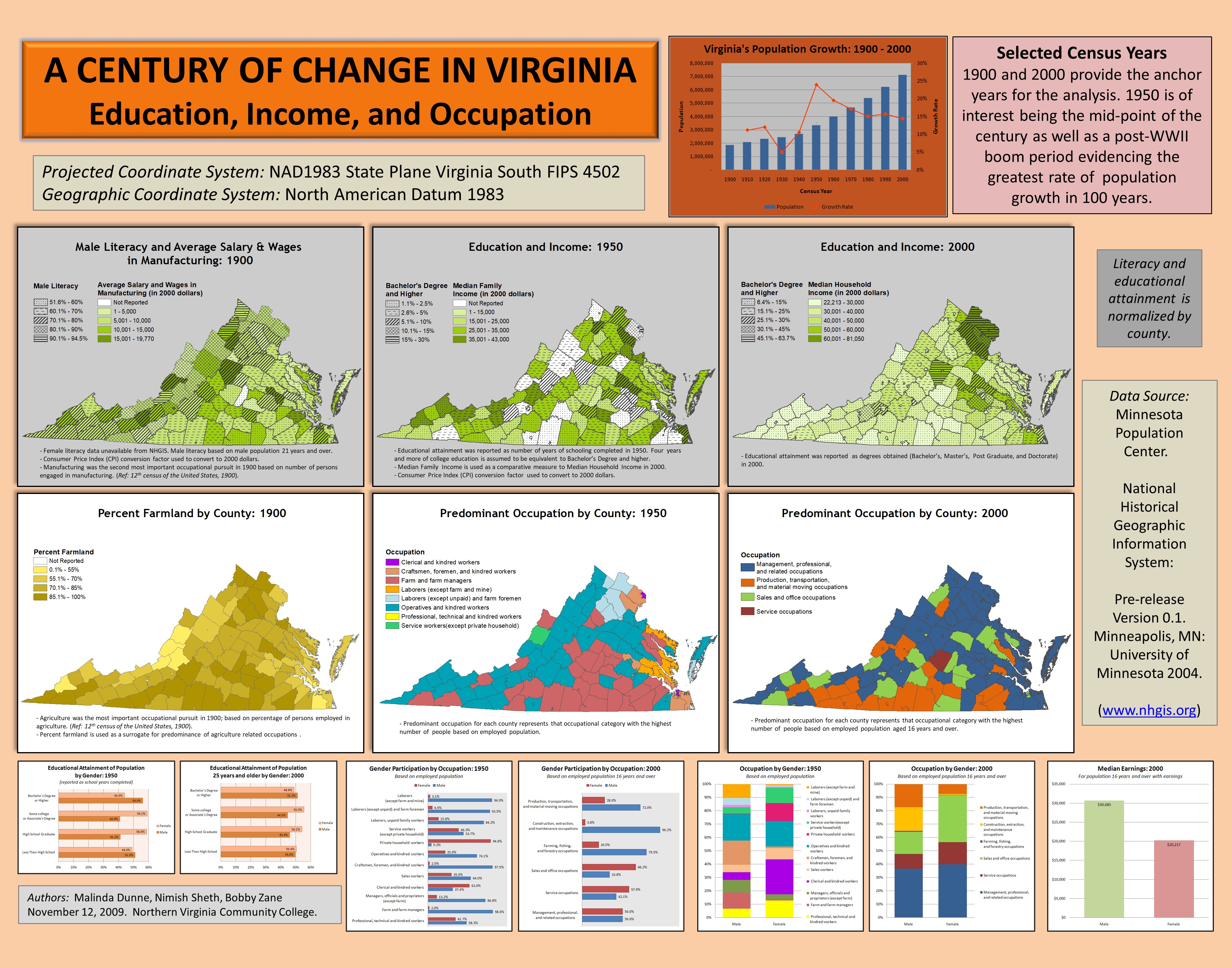
A century of change in Virginia, May 2010
In this project, the analysis looks at the the demographic patterns for the Commonwealth of Virginia from 1900 to 2000 through investigation of occupation, income, and educational attainment variables. The data for this project was sourced from the National Historical Geographic Information System (IPUMS NHGIS).
Characterizing wildfire threat for Franklin County, Virginia, May 2010
Natural wildfires are inherent to regenerative ecological cycles of forests. Assessing and managing wildfire threat in the wildland-urban interface (WUI) is an important natural resource management concern. The WUI is essentially the contact zone between human development and wildland vegetation–where the two intermingle or abut each other. Of particular interest is the threat to life and property, and thus, the heightened need to manage the wildfire risks in the WUI.
Wildfire propensity is predicated on a variety of factors. Topographical features such as terrain slope and orientation as well as surface vegetation combine to form specific fire hazards. A region’s fire history can indicate future ignition hazard. The WUI, based on housing density and vegetation cover, delineates the human-wildland contact zone.
In this project, I have used Geographical Information Systems (GIS) to quantify the fire threat for Franklin County, Virginia and its WUI areas at risk from wildfire ignition and spread. I have created a set of maps to present the geographical assessment and to visualize the fire threatened WUI. These maps can aid natural resource managers in hazard planning and mitigation, and to identify areas requiring further detailed analysis.
Identifying food deserts in South Dakota, December 2009
Many U.S. residents face an abundance of food choices in a traditional supermarket. Yet for many others, access to healthy and affordable food is limited or even non-existent. Population decline in rural communities due to shrinking economies results in fewer grocery outlets serving larger areas. A region with diminished or non-existent geographic access to retail food is considered a food desert (Morton et al., 2005).
The term “food desert” is believed to have originated in the U.K. in the 1990s to describe the lack of access to retail food due to the closure of grocery stores in deteriorating neighborhoods of large cities. In the U.S., however, absence of grocery stores is an insufficient measure. The large presence of convenience stores and mini-marts does provide for access to food but clouds the importance of access to quality and healthy food at competitive prices. Alternately, a food desert community in the U.S. is more appropriately defined based on travel distance to large food retailers (Morton and Blanchard, 2007).
Here, I have used the food desert definition generally accepted in the literature to identify and characterize food deserts in South Dakota.
Selecting suitable sites for wind farms in Virginia, May 2009
Much of the current scientific evidence indicates that the rapid and unsustainable consumption of fossil fuels in meeting increasing energy demand necessitates the aggressive adoption of renewable and clean energy options. Wind energy is a leading clean energy alternative with demonstrated successes. A key highlight in a May 2008 report by the U.S. Department of Energy (U.S. DoE) titled “20 Percent Wind Energy by 2030,” is the need to increase wind turbine installations by threefold from year 2006 to 2017.
The purpose of this project was to identify suitable on-shore sites for utility-scale wind farms in Virginia i.e., locations where large wind turbines can be exploited (cccording to the American Wind Energy Association, utility-scale wind turbines have at least 700kW capacity). The site selection process was based on criteria including land use, population constraints, transportation access, and existing energy infrastructure. Geographic Information Systems (GIS) was used to conduct the necessary manipulation and analysis of geographic data and visualize the outcome. The proposed solution presents four sites suitable for wind farms and screening of additional criteria in future work.
Comments